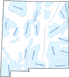
Geologic Regions
Shapefile

Tags
Geology, Geologic Structure, Geologic Basins
Polygon layer created to highlight general boundaries of subsurface geologic basins and uplifts of New Mexico and their influence on oil and gas production within the state.
Basins and structural influences are derived from publications of New Mexico Geological Society (http://nmgs.nmt.edu/), West Texas Geological Society (https://www.wtgs.org/), and USGS publications (https://www.usgs.gov/). Production status (PRODCODE) was determined by overall current oil and gas production status (as of 01/04/2010) of wellbores within each structure.
Projection: UTM Zone 13N - NAD83 (meters)
Attributes:
Label: LABEL
Definition: Basin or geologic structure name.
Label: PRODCODE
Definition: Production Status - Hydrocarbon status as of 1/4/2010.
Attribute Values:
Current
Potential
Structural Influence
Testing
San Juan Basin Geology, New Mexico and Colorado, USGS (https://catalog.data.gov/dataset/san-juan-basin-geology-new-mexico-and-colorado-sjbgeolg)
Numerous publications by New Mexico Geological Society (http://nmgs.nmt.edu/publications/) and West Texas Geological Society (https://www.wtgs.org/wtgs-publications/) were utilized in determining boundaries of geologic regions in the rest of the state, as was personal experience of the author. Many thanks to Ron Broadhead of New Mexico Bureau of Geology for his assistance and inspiration.
Eleanore Nestlerode
(505) 827-5727
enestlerode@slo.state.nm.us
logic@slo.state.nm.us
No warranty is made by the New Mexico State Land Office as to the accuracy, reliability or completeness of these data.
Extent
West -109.329416 East -102.944073 North 37.065179 South 31.310789